Home
Weather London
WeatherRadar
RainfallRadar
TemperatureRadar
WindRadar
LightningRadar
Weather News
Editor's Pick
Discover the app
Weather widget
Contact us
Apps
Career
    Home / Editor's Pick /

    Former hurricane to record-breaking storm - Isaias affecting Europe

11:00
14 October 2026

Isaias affecting Europe
Former hurricane to record storm

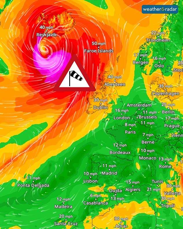
A massive storm system has developed over the North Atlantic. It has formed from the remnants of Hurricane Isaias, which made landfall on the US coast at the weekend.

Over the sea and along the southern coast of Iceland, the storm is reaching wind speeds of around 125 miles per hour.

Did you know?

Within just 24 hours, the air pressure associated with the low-pressure system has fallen by more than 50 hectopascals. We meteorologists call this ‘explosive cyclogenesis’. This is when a low-pressure system intensifies explosively within a short space of time.

The full force of the hurricane will not make landfall. However, Ireland and Scotland will feel the effects of the storm’s outer bands. At the same time, the low-pressure system is affecting wind patterns across large parts of central and south-western Europe.

Our global WindRadar shows the powerful storm system south of Iceland.

With the wind shifting to the south-west, warm air is flowing into Central Europe. As a result, temperatures are rising to around 20°C. In Spain and the south of France, it will get even warmer, with highs of around 30°C.

See the warmest temperatures todayTemperatureRadar
Weather & Radar editorial team
More on the topic
Tornadoes rage across Sicily. Cars sent flying. . . Saturday, 10 October 2026
A split image showing a tornado off the coast of Sicily on the left-hand side. A dark cloud funnel extends down to the ground or the water’s surface; houses and palm trees can be seen in the foreground. On the right, a weather map near Marsala shows heavy rainfall in pink and blue, numerous flashes of lightning as yellow dots, and a white whirlwind symbol.
Saturday, 10 October 2026

Cars sent flying

Tornadoes rage across Sicily
Gales build again for Ireland. Turbulent week ahead. . . Monday, 12 October 2026
Wind map showing 40 mph winds near Galway, 30 mph near Cork, 25 mph near Dublin and 23 mph near Belfast, with a windsock symbol.
Monday, 12 October 2026

Turbulent week ahead

Gales build again for Ireland
Dull start to the week under cloud cover. Little sun to be seen. . . Monday, 12 October 2026
Weather map showing extensive cloud over the UK and Ireland, a broad blue rain band approaching western Ireland and temperatures of 12–17°C.
Monday, 12 October 2026

Little sun to be seen

Dull start to the week under cloud cover
All weather news
This might also interest you
New records for England and Wales. Broken again tomorrow?. . . Thursday, 25 June 2026
Temperature map of southwest Britain on 25.06 showing extreme heat across southern Wales and southwest England, with Bute Park in Cardiff highlighted at 34.2°C and Yeovilton at 36.4°C amid widespread deep red heat zones.
Thursday, 25 June 2026

Broken again tomorrow?

New records for England and Wales
A stormy week in the skies above. Your weather - Your shots. . . Sunday, 30 August 2026
Split image showing lightning branching beneath dark storm clouds above rooftops on the left and an orange-pink sunset over a calm sea on the right.
Sunday, 30 August 2026

Your weather - Your shots

A stormy week in the skies above
Long-term trends need a pinch of salt. 40 °C in July?. . . Tuesday, 30 June 2026
Temperature radar of 2022 heatwave where the all-time temperature record in the UK was set. Warning symbol overlain.
Tuesday, 30 June 2026

40 °C in July?

Long-term trends need a pinch of salt
All articles
Weather & Radar

Weather & Radar is also available on

Google Play StoreApp Store

Company

Contact us Privacy Policy Legal info Accessibility statement

Services

Uploader

Socials

facebooktwittertikToklinkList