Home / Editor's Pick /

Heavy rain hits Luxembourg, western Germany, Belgium and eastern France – several locations flooded

10:36
9 September 2025

Towns flooded
Heavy rain hits Europe

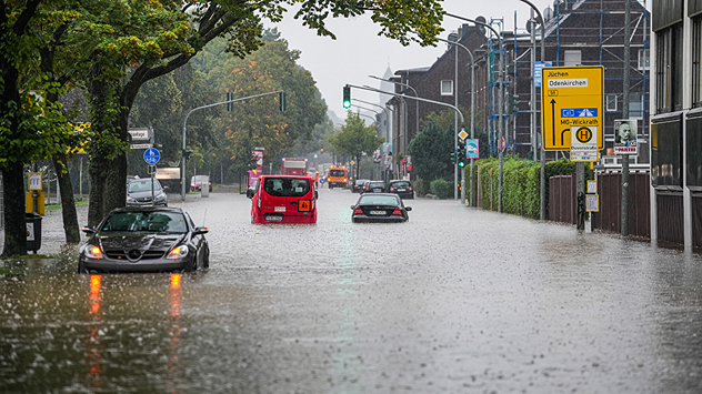
Cars stand in a flooded street in Mönchengladbach, which is under water after heavy rain.In Mönchengladbach in western Germany, the streets are knee-deep in water in some places after heavy continuous rain. - © dpa

Heavy rainfall has caused flooding in Luxembourg, Western Germany, Belgium and eastern France. In some cases, entire residential areas were underwater.

Over 100 litres of rain per square metre fell in southern Luxembourg. As a result, roads and underpasses were flooded, and seven people had to be rescued from their cars. Cellars were flooded in Luxembourg City and several other locations.

In north-eastern France, the Moselle department was particularly affected. A mudslide occurred in Himeling. Numerous problems also arose in southern Belgium. In Germany, the storms particularly impacted the west of North Rhine-Westphalia.

There, the fire brigade rescued several people from the floodwaters. Numerous cellars and streets are still partially underwater. Sandbags are protecting the houses from the rain floods. The heavy rainfall will ease off by Tuesday evening, so the worst is now over.

Settings for external content

Privacy Policy
Tommy Kühnlein
Ryan Hathaway
with material from dpa
More on the topic
Map of Europe showing low pressure over Russia and a strong cold air flow towards Eastern Europe. Significant drop in temperatures across large parts of the east.
Thursday, 11 December 2025

Frost and snowfall

Cold air intrusion in Eastern Europe
Map comparison showing 44 degrees in Indulkana and minus 51 degrees in Olenyok. Coloured temperature ranges show stark global contrasts.
Tuesday, 9 December 2025

Global extremes

Almost 100 degrees difference in temperature
Split image showing a towering storm cloud with rain shafts over the sea on the left and a vivid red aurora illuminating the night sky above residential rooftops on the right, divided by a curved white line.
Tuesday, 9 December 2025

Your weather - Your shots

Autumn captured by you
All weather news
This might also interest you
Weather graphic showing rain and wind fields over the Canary Islands and a central warning symbol.
Friday, 12 December 2025

Storm and rain

Turbulent weather in the Canary Islands
Split weather map showing the UK and Ireland. The left side illustrates strong winds circulating around a low-pressure system, with gusts of 20–30 mph highlighted in orange and yellow. The right side shows radar imagery with widespread blue rain bands and patches of thunderstorms, especially over northern England and Scotland.
Thursday, 28 August 2025

Breakfast brief

Remaining widely unsettled
Split weather map showing UK wind speeds in orange-red shades up to 40 mph on the left and warning levels in green-yellow on the right, with a central wind warning sign.
Wednesday, 22 October 2025

Warnings active

Storm Benjamin impacts the UK
All articles
Weather & Radar

Weather & Radar is also available on

Google Play StoreApp Store

Company

Contact us Privacy Policy Legal info Accessibility statement

Services

Uploader

Socials

facebooktwittertikToklinkList