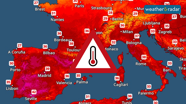
Home / Editor's Pick /

Extreme heat in the Mediterranean: Hot air spreads

07:00
7 August 2025

Holiday hot spots
Intense heat in the Mediterranean

Temperature map showing very hot temperatures across the Mediterranean.The Temperature Radar forecast for Sunday.

In Southern Europe, popular holiday hotspots are experiencing an intense blast of heat, with no end in sight.

Spain is currently experiencing particularly high temperatures. In Madrid, temperatures are expected to reach 40 degrees today. The country is set to heat up even further over the coming days.

The heat also continues to spread across southern France and into Italy over the coming days. On Sunday, peak temperatures of 40 degrees and above are expected in Montpellier. Temperatures in Rome will also rise above 35 degrees.

Forecast for selected cities:

Seville

Sa
11
12
Su
4
13
Mo
8
15
Tu
7
14
We
4
14
Th
7
14
Fr
6
14
Sa
9
16
Su
8
16
Mo
9
16
Tu
7
15
We
8
13
Th
9
16
Fr
8
16
Max (°C)
Min (°C)
moreless

Montpellier

Sa
14
14
Su
12
12
Mo
8
9
Tu
7
11
We
5
12
Th
3
12
Fr
4
10
Sa
4
10
Su
4
10
Mo
3
10
Tu
3
9
We
0
7
Th
0
7
Fr
-1
6
Max (°C)
Min (°C)
moreless

Rome

Sa
4
15
Su
6
15
Mo
9
15
Tu
9
12
We
6
9
Th
5
12
Fr
4
13
Sa
2
12
Su
1
11
Mo
1
10
Tu
3
12
We
3
12
Th
3
12
Fr
3
11
Max (°C)
Min (°C)
moreless

The nights will not bring any relief either. Minimum temperatures will generally range between 20 and 25 degrees. The temperature curve will only start to dip next week.

Sebastian Keßler
Ryan Hathaway
More on the topic
pinecones
Thursday, 11 December 2025

Winter helpers

How pine cones aid the weather forecast
Map comparison showing 44 degrees in Indulkana and minus 51 degrees in Olenyok. Coloured temperature ranges show stark global contrasts.
Tuesday, 9 December 2025

Global extremes

Almost 100 degrees difference in temperature
The weather map shows extremely low temperatures in Canada.
Monday, 15 December 2025

Minus 53 degrees

Record cold in Canada's Yukon Territory
All weather news
This might also interest you
Split weather map showing the UK and Ireland. The left side illustrates strong winds circulating around a low-pressure system, with gusts of 20–30 mph highlighted in orange and yellow. The right side shows radar imagery with widespread blue rain bands and patches of thunderstorms, especially over northern England and Scotland.
Thursday, 28 August 2025

Breakfast brief

Remaining widely unsettled
Friday, 22 August 2025

Breakfast brief

Sunny start for some, overcast later
Monday, 25 August 2025

Bank holiday outlook

Warm day turning gusty in places
All articles
Weather & Radar

Weather & Radar is also available on

Google Play StoreApp Store

Company

Contact us Privacy Policy Legal info Accessibility statement

Services

Uploader

Socials

facebooktwittertikToklinkList